Ok Tedi Environment Rehabilitation?
In 1998 OTML started the dredging operation at Bige, which
is a village located just above the junction to the Fly River. A trench
was cut into the river bed, 10 m deep, and 800 m long, where all particles
of the size of sand are trapped, that arrive from upstream. When the slot
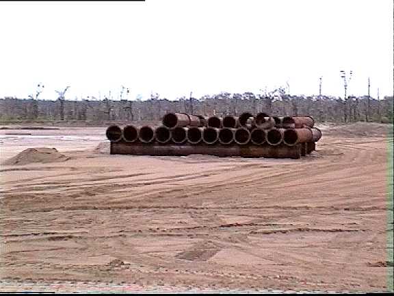
is filled after two weeks, a dredger boat will suck the sand, and the slurry
is pumped on land through thick pipes. There it will pass a settling pond.
The water is deviated back to the river. The sand deposit is built as terraces,
that will rise in steps 30 m above ground.
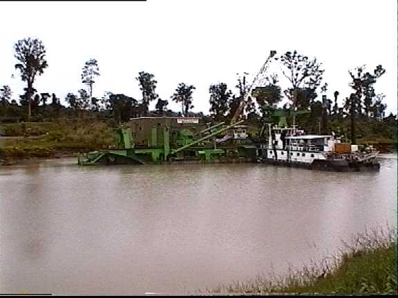
Dredging boat "Bige" at its berth
A very familiar sight to Hamburgians: harbour basins and the shipping channel
have to be dredged permanently. Since the fine sediments are too contaminated,
they have to be disposed on land. Space is scarce and expensive in an urban
region, so the Hamburgian harbour dredge is piled to hills with a final
elevation of 40 m. The sand fraction, that does not adsorb contaminants
to a degree like silt, is used to elevate marshland ground to prepare industrial
and harbour sites, and as drainage layers in the silt deposit hills. Only
the rainforest in the background reminds, that this is Bige, not Hamburg.
To OTML's experience, the sand fraction is completely recovered from the
Ok Tedi, which yields 18 million tons per year. It is not known, how much
of the sand is of natural origin. If all sand came from the mine - the
assumption most favourable to OTML - 30% of the input from Mt. Fubilan
would be removed from the river at Bige. 30% of mine input is coarse material,
that fills the river bed upstream. 40% of mine waste, essentially the fine
tailings, pass the sediment trap. The Bige dredge deposit is only a solution
for a minor quantity of the mine's waste, and it will work only in the
second half of the mine's life. OTML did not offer any solution for 70%
of the waste, that will continue to fill Ok Tedi and the Fly River for
the next ten years.
OTML and its main shareholder BHP were accused in Australia by landowners
of the Lower Ok Tedi and Middle Fly, to compensate the damage. In the out-of-court
settlement in 1996, OTML promised to search for a solution for the tailings
problem. Since tailings are probably the most serious threat, the precautionary
principle requires, to start operations to dispose the tailings safely,
now. A study - revised and released in 2000 - investigated the construction
of a tailings pipeline from the mine to the Bige deposit. It says, that
a tailings-pipeline is feasible. There are no major obstacles, to build
tailings into the sand deposit at Bige. However, the cost of US$ 130 million
is scaring OTML. It seems, OTML will do studies on the issue, till it will
become obsolete in 2010. Another lawsuit by OTML's opponents of 1996 has
been brought forth. Even the World Bank, that reviewed OTML's Mine Waste
Management Plan on request of PNG government, criticizes the lack of options
offered by OTML.
Riverbed aggradation by the coarse fraction of waste has not even been
considered, yet.
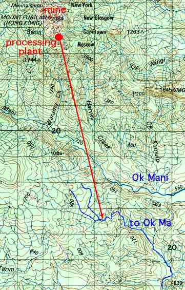
The disposal of tailings is an open question since mining started. Government
had imposed to OTML, to build a dam to retain tailings. A tunnel was drilled
from the processing plant, beyond the Ok Mani valley into the the watershed
of Ok Ma. This river tributes to the Ok Tedi downstream at Ningerum.
 After a landslide, the tailings dam project was abandoned. Government set
levels of pollution, that allowed OTML to discharge tailings without any
treatment.
After a landslide, the tailings dam project was abandoned. Government set
levels of pollution, that allowed OTML to discharge tailings without any
treatment.
There are several questions open in this case. Why was the adjacent
Ok Mani not proposed for the dam, but the Ok Ma, where one had to cross
a water divide? Why did the PNG government not listen to its technical
staff (see the "Smoking Gun Files")? Was OTML ever seriously determined
to build a tailings disposal, or was the Ok Ma dam but an expensive alibi,
to exclude an even more expensive true solution? The 1996 agreement raised
the problem of tailings disposal again, but after wasting four years of
studies, to divert the tailings by pipeline to the Bige dredge disposal,
OTML is still not willing to to anything about it.
The dredge operation at Bige aims at a reduction of inundation of the
floodplain, by keeping the river bed open, and allowing an easier drainage
and retreat of water after flooding. Have
a look! To the date, a significant recovery of vegetation was
not observed. The landowners, who were invited to the meeting at Bige,
declared, that nothing had changed so far, and gardening was still impossible.
Monitoring data were not presented, e.g. an aerial photograph survey of
the extension of the dieback area. The optimistic assumption of OTML, the
jungle would quickly reclaim its territory, was not proved, and the question
remains open, what kind of jungle on which scale of time will take the
place.
Monitoring data of aquatic life were not represented, nor are they
published on the internet. There is no fish stock statistics over the lifetime
of the mine, that might prove the magnitude of impact, or a recovery related
to the dredge at Bige.
Insufficient monitoring (or publication of monitoring results) does
not allow a quantitative assessment of impacts of the mine at present,
nor of claims to be justified, nor of impacts in the coming ten years of
mine operation. A mine closure plan, that would make sense ecologically,
has to be based on a quantitative description of damage, to calculate the
amount of work, money, and time to rehabilitate the environment. The monitoring
parameters are not set, that indicate progress or failure. With respect
to environment outside the mining pit, the "Mine Closure Plan" cannot be
called a plan.
Significant for these deficits of information are the recent demonstrations
of the West Ningerum people. On january 4, 2001, West Nigerums gathered
at Tabubil, to claim that fish stock in two tributaries of the Ok Tedi
river have declined substantially. The Ok Birim and Ok Tarim join Ok Tedi
from the west between Ningerum and Bige. OTML denied any resposibility,
recent studies of water samples by government scientists had found there
was no basis for the claims. Clean water in a river, that is not effected
by mining, goes without saying. But the breakdown of fish stock in the
Ok Tedi makes it highly probable, that fish stock of the Ok Birim is affected,
too, at least fish, that migrate like barramundi. West Ningerums, OTML,
and government agreed, to do an independent study. One wonders, why among
so much research, there is no fish stock statistics, that might proove
the Ningerums' claim right or wrong instantly.
Original issue April 2001
last update
 Index of Ok Tedi pages
 back to Homepage
|

 rettet-die-elbe.de