UMWELTATLAS HAMBURG
ENVIRONMENTAL ATLAS HAMBURG
5. Das haben wir nun davon - Umweltzustände
State of Environment
bottom
Abflusssimulation - Flow Simulation
The "flood of the century" on the river Elbe in August 2002 hit vast areas
along the river and some of its tributaries unprepared. Though the flood
on the neighbouring river Oder in the summer of 1997 should have been a
warning, an efficient alarm scheme had not been established. The demand,
that state administration should implement a coherent river basin management,
was raised afterwards.
The following considerations outline a model, to calculate the resulting
flow from a watershed from the properties of terrain and landuse. The geografical
information system (GIS) "Idrisi"
(version 2 for WINDOWS) was used to create the model.
Rain falling within a watershed will reach the exit of the river basin
after some time, which depends on the distance of an unit of area to the
exit, the slope (the steeper the faster), and the orientation of the slope
area unit towards the exit point. An arbitrary landscape was created of
40 x 30 area units (pixels), with a rim of 100 units (meters) to the west,
and 50 units to the east, and a river meandering from north to south through
a valley to the exit at a level of 0 units. The digital elevation model
(DEM) was produced from digitized contours by the contours interpolation
module of Idrisi, refined by mean and median filtering. An area is scetched
in the DEM, where different landuses will be simulated, later.
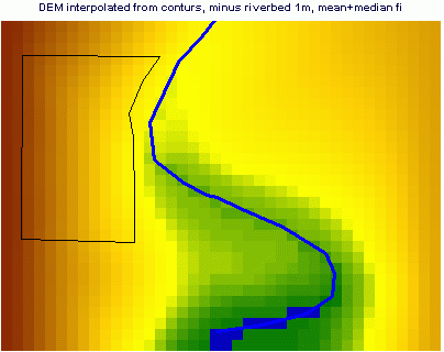
Picture 1: DEM model
From the DEM, slope and ascpect are derived. Idrise offers a module
"VARCOST", that calculates the least time it will take to reach each pixel
in the DEM from a set of target pixels. In this case, one target pixel
at the south exit of the valley is set. In addition to distance, slope,
and aspect, an isotropic friction is assumed, to move from one pixel to
another. On land, the friction is set to an arbitrary value of 2.
The riverbed, where water flows much faster, is set to a value of 0.1.
As the most simple case, a uniform precipitation for the duration of
1 time unit is assumed. In relative time units from 0 = the target pixel,
to 46 = the most remote pixel in the northeast corner, VARCOST yields picture
2
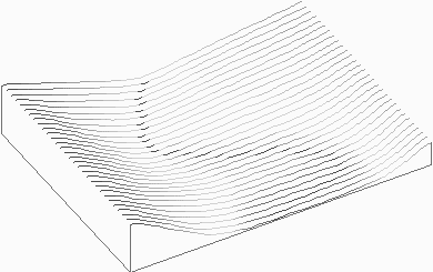
Picture 2: animation in 3D-view of arrival of the water flow, displayed
in steps of 5 time units
The area delineated in picture 1 was overlayed to the isotropic friction
image, that either an urban surface with a roughness of 1, or a forested
surface with a roughness of 3 replaced the general value of 2. Pictures
3 and 4, and picture 5, show the results.
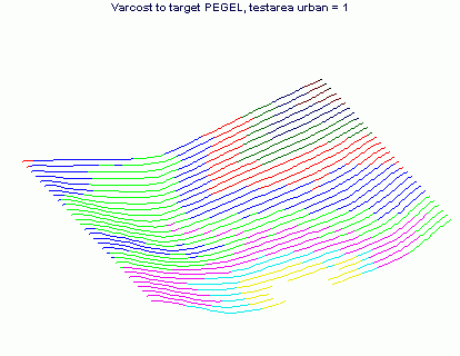
Picture 3: water from the western slope with an urban area arrives earlier
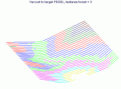
Picture 4: water from the western slope with a forest area arrives later
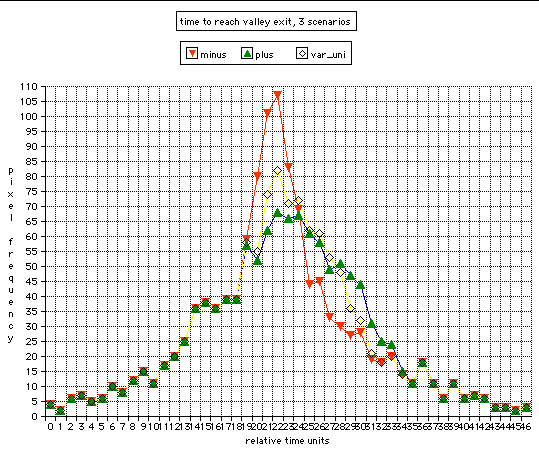
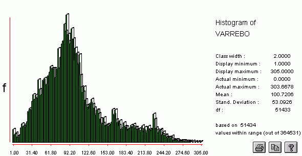
Picture 5: diagram of frequency of pixels per time unit arriving at
exit of catchment,
3 landuse scenarios
yellow line = homogenous
red line = urban area on the western valley slope
blue-green = forest area on the western valley slope
Compared to a homogenous landuse, from an urban area more water arrives
at one time at the exit, while with a forested area the peak flow is lowered
and distributed to later time units.
The upper part of the Elbe catchment, the Bohemian Basin, was chosen
to apply the idea to the real world. The US Geological Survey provides
DEM
and landuse maps, derived from satellite imagery, for all parts of
the world. The river net was taken from ESRI.
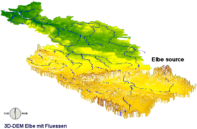
Picture 6: The original DEM from USGS was imported to Idrisi, and the
Elbe catchment cut like a cookie. Geografic projection is set by USGS to
Lamber Azimuthal Equal Area, with a center at 20 East, 55 North. Pixel
width measures 1 km, elevation is in meters, from sea level = 0 to the
highest of 1457 m. Actually, the Riesengebirge (Giant Mountains, south-east
corner, source of the Elbe, Czech: Labe) peak at 1600 m, however, in a
coarse grid, accuracy of elevation is limited. In the Bohemian bowl,
the Elbe is joined by Moldau/Vltava and Eger/Ohre, breaks through the northern
rim, and after passing the North German Lowlands, discharges into the North
Sea.
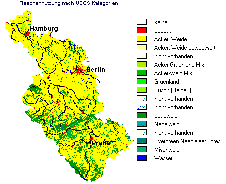
Picture 7: Landuse derived from satellite imagery, according to USGS
Land Use/Land Cover System; dominant landuse is cropland/pasture, followed
by forests.
A flow calculation by the varcost-function was done for the Bohemian
Basin, where frictions were assigned to landuse in this arbitrary scheme:
| friction |
Frequency=km2 |
landuse |
| 0.1 |
1291 |
riverbed |
| 1.0 |
471 |
urban |
| 2.0 |
33153 |
Cropland/Pasture |
| 3.0 |
2797 |
Cropland/Grassland Mosaic |
| 4.0 |
1 |
Grassland |
| 5.0 |
683 |
Cropland/Woodland Mosaic |
| 7.0 |
56 |
Shrubland |
| 8.0 |
12159 |
Forest |
Along the major riverbeds, water from these pixels readily arrive at the
target = exit at the break through the north rim, while from the western
Eger valley, with a high share of forest area, time consumption is highest.
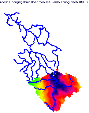
Picture 8a: time consumption (relative units) for each pixel in
the Bohemian watershed, to reach the exit pixel, as a function of slope
and aspect (from DEM), and friction (from landuse)
Picture 8b: corresponding histogram of flow from the Bohemian watershed
The calculations, so far, yield flow-curves qualitatively similar to
measured flood levels, but they are not meant to make realistic predictions.
However, any model, any computer software, would start with basic parameters,
a DEM, the river net, and a landuse map. The capacity of soil, to subtract
trickle water from the surface flow, has to be added. The accuracy of the
maps has to be improved, and real friction factors have to replace those
chosen arbitrarily, here. Precipitation scenarios that vary in time and
space should be introduced (in Idrisi this can be done by crosstabulation).
The simulation has to be calibrated.
In the middle of that month of August 2002, the Bohemian bowl was covered
by extreme precipitation. From Prague, over Dresden, far down the Elbe
valley the flood wave innundated numerous cities and villages. The water
level curves are compiled from data provided by the German federal institute
of hydrology (Bundesanstalt
für Gewässerkunde). The data are not complete on the internet.
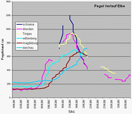
Picture 9: Water levels of the Elbe flood in August 2002, German part
from Czech border (Schoena) to Darchau, few kilometers upstream Hamburg.
Schoena, located on the Czech-German border, was hit by the highest
water level on August 16. The historic downtown of Dresden was innundated
one day later. On its way downstream Torgau, Wittenberg, Magdeburg, and
Darchau, the flood wave flattened and became broader. At Hamburg, the flood
volume dissipated into the branched harbour area and the broad estuary,
and did no harm.
One experience from the desastrous flood in August 2002 is, that reliable
and fast predictions are needed. No one could tell, when and where how
much water would arrive in the flood plain, and if the capacity of the
flood plain would be exceeded. Second, a flow model is needed for planning,
to prevent rapid and steep accumulation of flow. Forested areas as buffer
zones should be increased, urbanisation avoided at risk sites, rivers and
creeks no longer channelized, but their natural "roughness" and length
restored.
Klaus Baumgardt
top
Download simulation model Idrisi-files
zum Inhaltsverzeichnis-
Index Environmental Atlas Hamburg
|

 rettet-die-elbe.de